Other News
Ex-Hurricane Humberto could ‘re-intensify’ before hitting Ireland
Read more on post.
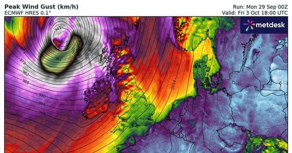
The remnants of Hurricane Humberto could batter Ireland, a forecaster has warned.
The ex-hurricane could “reintensify” when it interacts with the jet stream on Friday, Alan O’Reilly of Carlow Weather said. He added on Facebook: “Still uncertainty on the track so keep up to date and hopefully the worst of it stays away from Ireland.”
Humberto, which has been officially branded a Category 5 hurricane, has sparked alerts from the US National Hurricane Center for the Virgin Islands, Puerto Rico, Bermuda and sections of the US east coast. The hurricane will track northwestward across the Atlantic Ocean towards Ireland over the coming days.
Met Eireann is warning of chaotic conditions with plenty of rain in the coming days. Here is what the nationwide outlook says:
Today
“Patchy rain in Ulster will soon clear to leave a generally dry day albeit with lots of cloud. Further outbreaks of rain will develop in the west and northwest during this evening. Highest temperatures of 14 to 17 degrees with light to moderate southerly winds, freshening in the west later.
Tonight
“Tonight will be cloudy with outbreaks of rain and drizzle moving eastwards across the country. There’ll be mist and fog too. Lowest temperatures of 9 to 14 degrees with light to moderate southerly winds.
Tomorrow
“Tomorrow will be dull and misty with hill fog. There’ll be scattered outbreaks of rain and drizzle during the morning and early afternoon, then more persistent rain will spread across the country from the west during the late afternoon and evening. Highest temperatures of 14 to 17 degrees with light to moderate southerly winds, freshening in the west later.
Tuesday night
“Cloudy with mist and hill fog. Wet at first with widespread rain but the rain will become lighter and patchier by morning. Mild with temperatures not falling below 13 to 15 degrees, in a moderate to fresh southerly breeze.
Wednesday
“Cloudy with scattered outbreaks of rain, most frequent in the west and north. Highest temperatures of 15 to 18 degrees with a moderate to fresh southerly breeze.
Wednesday night
“Continuing cloudy with scattered outbreaks of rain. Mild with temperatures not falling below 13 to 15 degrees, in a moderate to fresh southerly breeze.
Thursday
“Wet and breezy with widespread rain, heaviest in the west and northwest. Highest temperatures of 14 to 16 degrees with a fresh southerly wind.
Thursday night
“Rain will clear eastwards early on Thursday night and it’ll become dry with clear spells for a time. However, more cloud will extend across the country from the southwest later in the night, bringing rain to the west and southwest. Lowest temperatures of 9 to 12 degrees with light to moderate west to southwest winds, becoming southerly.
Friday
“Another wet and breezy day on Friday with widespread rain, heavy at times. Highest temperatures of 16 to 18 degrees with a fresh to strong southerly wind.
The Weekend
“Becoming generally drier for the weekend, although some showers are likely, especially in the north and west.”
Join our Dublin Live breaking news service on WhatsApp. Click this link to receive your daily dose of Dublin Live content. We also treat our community members to special offers, promotions, and adverts from us and our partners. If you don’t like our community, you can check out any time you like. If you’re curious, you can read our Privacy Notice.
For all the latest news from Dublin and surrounding areas visit our homepage.